C-band 5G telecom delays and airline frustration
The airlines made their case to the FAA earlier this week, warning that the rollout of 5G service near airports could cause catastrophic disruption to both passenger flights and cargo shipments. “Unless our major hubs are cleared to fly, the vast majority of the traveling and the shipping public will essentially be grounded,” wrote the chief executives of American Airlines, Delta Air Lines, United Airlines, Southwest Airlines among others in a letter first reported by Reuters.
The US is not alone in this struggle. Last October, Canadians living near airports were informed that they will not get full 5G service. According to the Toronto Star, “The government said it is introducing the restrictions because there are concerns about possible interference between those airwaves — which are known as spectrum and carry wireless communications signals — and certain aviation navigation tools.”
This post was written by guest bloggers Mike Rudolph, Industry Manager for Aerospace and Defense, Steve Ajemian, Technical Account Manager for our Aerospace and Defense Accounts, and Rick Gentile and Babak Memarzadeh, Product Managers for Radar Toolbox and Sensor Fusion and Tracking Toolbox. Together, this team tracks and supports technical trends throughout the industry to enable engineers and scientists to better collaborate across disciplines such as Radar and 5G.
Analyzing for Interference
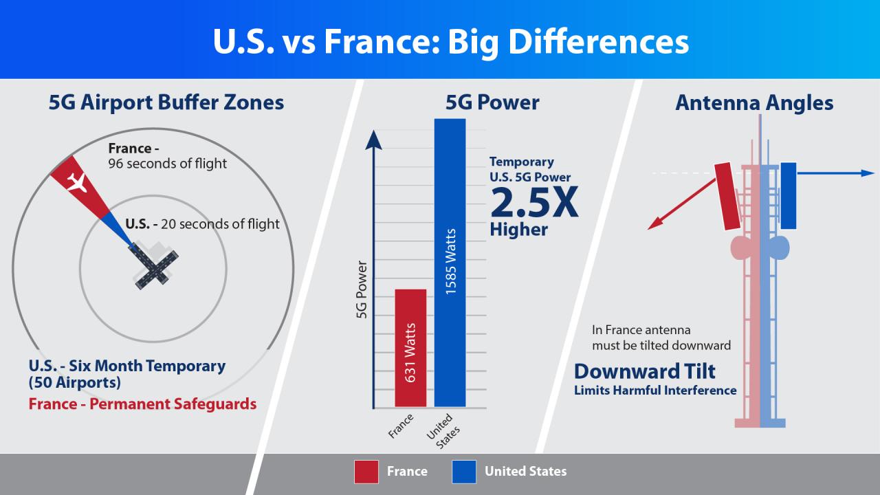
According to the FAA, the “deployments of 5G technology in other countries often involve different conditions than those proposed for the U.S., including lower power levels, antennas tilted downward to reduce potential interference to flights, different placement of antennas relative to airfields, and frequencies with a different proximity to frequencies used by aviation equipment.”
In the US, the concerns raised about possible interference are due to the region of spectrum within C-band that is being utilized for 5G communications. The 3.7 – 3.98 GHz band has been purchased by the wireless carriers AT&T and Verizon. This spectrum is in close proximity to the operating frequencies of radar altimeters which reside in the 4.2 – 4.4 GHz band. Radar altimeters are utilized by aircraft to measure the aircraft’s altitude relative to the local terrain during flight.
While the wireless industry has referenced successful 5G rollouts in other countries, there has not been a comprehensive study of the possible impacts to radar altimeters due to 5G systems operating in such close proximity within C-band.
According to NPR, “[…] former Federal Aviation Administration Administrator Michael Huerta, who served in the role from 2010-2018, points out the 5G towers near airports in other countries are either turned off or operating at low power near airports, with transmitters pointing down toward the ground and away from aircraft.”
“What really needs to happen is the very detailed technical analysis, airport by airport, aircraft type by aircraft type, to determine how real the interference potential actually is,” Huerta told NPR.
Defining the Problem Space
The concern of interference from 5G systems near airports is magnified by the fact that 5G base stations utilize directional antennas that can focus transmissions in very specific directions. These base stations also radiate at elevated heights to allow these transmissions to propagate over greater distances.
From the perspective of the radar altimeter, the primary concern with systems operating in close frequency proximity is due to “spurious emissions.” Spurious emissions are undesired out-of-band emissions into nearby frequencies that occur during transmission. These emissions can degrade the performance of the receiver operating nearby (the radar altimeter in this case) due to RF energy leaking into this band, which could prevent an accurate determination of flight altitude. Characterizing the level of interference observed at the radar altimeter is critical to understanding what performance degradation could be experienced.
Lastly, these scenarios involve aircraft taking off and landing, with the position and altitude changing over time. Since the distance relative to the 5G base station will be varying, this adds additional complexity to the analysis.
Modeling this scenario in MATLAB
With MATLAB, you can build a high-fidelity model of this scenario and analyze the potential for interference from 5G transmissions to radar altimeters. The scenario can be decomposed into three major parts: 5G waveform generation and transmission, radar altimeter modeling, and scenario modeling.
-
5G Waveform Generation and Transmission
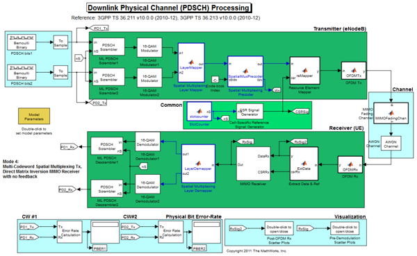
Using the 5G Toolbox, users can generate a range of standard-compliant 5G waveforms to investigate the out-of-band emissions when transmitting in C-band (3.7 – 3.98 GHz). Custom waveforms can also be created and generated targeting the bands of interest for this type of analysis.

5G Waveform Generator App
Phased Array System Toolbox enables users to model a representative antenna array for a 5G base station. These base stations utilize adaptive beam steering to dynamically point antenna beams towards user equipment. Modeling the 5G waveform and the radiated power together can provide a representative interference source to characterize the out-of-band emissions as they propagate over the air.

Phased Array Beamforming
-
Radar Altimeter Modeling
Using the Radar Toolbox, you can model the radar altimeter and assess performance with and without 5G interference present. You can also model cases where interferers such as when a 5G base station is transmitting nearby. You can model the radar altimeter to generate the received in-phase and quadrature (IQ) signals. By applying signal processing algorithms on the received IQ signal, you can assess the effect of interference on the output of the radar altimeter.
-
Scenario Modeling
Aircraft performing a takeoff or landing maneuver can be readily modeled using Radar Toolbox. Modeling the aircraft flying relative to the 5G Base Station enables the characterization of a range of interference conditions experienced over the course of the flight trajectory while accounting for the RF propagation of the 5G transmissions.
High-Fidelity Modeling

Model radar air traffic systems and radar altimeters
With MATLAB, you model complex wireless and radar scenarios. These models can be used to characterize the effects of interference and inform decision-making on appropriate mitigations to allow these types of systems to co-exist. If your team is interested in a demo of these capabilities, please reach out to speak with one of our industry experts.
Here are some additional resources:


댓글
댓글을 남기려면 링크 를 클릭하여 MathWorks 계정에 로그인하거나 계정을 새로 만드십시오.