Nor’easters and Wind Roses
Where I live, in the northeast part of the United States, we have a special storm that goes by the name “nor’easter”. Do we call it that because that’s where we live? No. We call it that because, during a nor’easter, the wind blows hard and steady from the northeast. It blows so hard, in fact, that it knocks the TH right out of the word NORTHEASTER, leaving behind only a squeaky, dangling apostrophe.
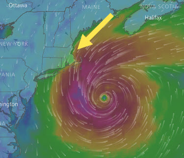
Next question. Why does the wind blow from the northeast? Two years ago I took this snapshot of a storm called Jose, which was in the process of downgrading from a hurricane to a tropical storm. This picture rather spectacularly illustrates the phenomenon. A big cyclonic storm rotates counterclockwise in the northern hemisphere, and this is what it looks like when it cuts across the coast like a circular saw blade. That northeast wind is the teeth of the storm. Not every storm looks like this, but it happens often enough to get a special name: nor’easter. Now you know.

Hurricane Jose in September 2017. Image courtesy of Windy.com
Now let’s go find some data and see if it backs up what we see in the picture. Have a look at NOAA Buoy 44013, also known as Boston Approach Lighted Buoy BF NOAA 44013. Nice looking kid, eh?

Buoy 44013 sits in 33 fathoms of cold Atlantic water just outside Boston harbor. Lovely oceanfront views. Good seafood nearby.

This gives it a perfect vantage point to tell us about the winds of September 2017. Luckily for us, the NOAA has free meteorological data going back several years. Let’s run this file through the Data Import tool. Incidentally, it’s really a joy using the Data Import tool with data like this. You just enter the URL and it takes care of the rest.
I’m going to take the raw data and make a timetable with wind measured in knots.
load september2017.mat
dt = datetime(w2017.YY,w2017.MM,w2017.DD,w2017.hh,w2017.mm,0);
% Let's present wind in knots
% Conversion factor from meters/sec to knots
mps2kts = 1.94384;
wind = timetable(dt,w2017.WDI,w2017.RWSP*mps2kts);
wind.Properties.VariableNames = {'direction','speed'};
Now for a quick plot.
startDate = datetime(2017,9,1);
endDate = datetime(2017,9,30);
stackedplot(wind(wind.dt>=startDate & wind.dt<=endDate,:));
title('Wind Direction (deg), Speed (knots)')

Consistent with the picture, it’s clear something significant happened between September 19th and September 24th. And check out that nifty stackedplot command! Perfectly matched for the timetables in your life.
Now we’re ready for the main event: Daniel Pereira‘s excellent File Exchange entry Wind Rose.
Daniel has done a number of impressive things with his code.
- It’s lavishly documented. It even has its own website! Does your code have its own website?
- It has lots and lots of options, but it can still be called with just two simple inputs.
- Daniel responds to comments and keeps improving it.
This work has paid off in the form of consistently high ratings and downloads.
So what is a wind rose? A wind rose is a kind of radial frequency histogram. It shows you, for a given location, where and how hard the wind is most likely to blow.
These are the winds at Buoy 44013 for all of 2017. That’s 17,392 individual measurements, in case you’re wondering.
clf
WindRose(wind.direction,wind.speed, ...
    "vWinds", [0 5 10 15 20], ...
    "lablegend", "Wind Speed in knots");
title('Wind Rose for 2017')

This wind rose is much easier to interpret than two spidery stacked plots! It looks like the wind most often comes in from the north and west, but when it blows from the southeast, it tends to blow harder. But notice that it doesn’t come very often from the northeast.
Now let’s focus on the month of September.
startDate = datetime(2017,9,1);
endDate = datetime(2017,9,30);
ix = (wind.dt >= startDate) & (wind.dt <= endDate);
clf
WindRose(wind.direction(ix),wind.speed(ix), ...
    "vWinds", [0 5 10 15 20], ...
    "lablegend", "Wind Speed in knots");
title('Wind Rose for September 2017')

Bingo! That extended period of steady northeasterly wind sticks out like the proverbial sore sticking thing.
Here’s what it looks like if we animate the wind rose across September. Each frame is a snapshot of a three-day moving window. Better batten down the hatches before September 19th.

And thank you to Daniel for the beautiful Wind Rose!
For readers interested in exploring the latest polar axes tools in the R2024b release, check out our article on compassplot.


Comments
To leave a comment, please click here to sign in to your MathWorks Account or create a new one.